Overview
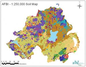
In Northern Ireland, a very diverse parent geology (both solid and drift) has been complicated by the effects of glaciations, variation of climate (spatially and temporally) and changes in vegetation. This, in combination with the overarching influence of man, has served to create a wide diversity of soil types in a relatively small region. Soil Survey is the process of identifying and mapping soils in the environment, which have similar physical appearance and behaviour and are developed from the same parent material. The Soil Survey of Northern Ireland actively mapped the distribution of these soils throughout the 1990s, and now forms part of the Agri-Environment Branch within AFBI. The distribution of soils with Northern Ireland is illustrated in the 1:250,000 General Soil Map below:
See also: Soil maps and soil survey
For more information contact: Soils group
